What is a Datum?
The Earth is shaped like a flattened sphere. This shape is called an ellipsoid. A datum is a model of the earth that is used in mapping. The datum consists of a series of numbers that define the shape and size of the ellipsoid and it's orientation in space. A datum is chosen to give the best possible fit to the true shape of the Earth.
There are a large number of datums in use. Many of them are optimised for use in one particular part of the world. An example is the Geodetic 1949 datum that has been used in New Zealand. Another example, familiar to GPS users, is the WGS-84 datum. WGS-84 is an example of a datum that is used globally.
Latitude and longitude are commonly used to refer to a specific location on the surface of the Earth. It is important to keep in mind that latitude and longitude are always specified in terms of a datum. The latitude and longitude of your current position are different for different datums. For example, the Cathedral in central Christchurch is at 172.63658E, 43.53103S in WGS-84 coordinates and 172.36344E, 43.53270S in Geodetic 1949 coordinates. If you are working with latitude/longitude coordinates and you get an error of a couple of hundred metres, you most likely are using the wrong datum.
New Zealand is changing to a new coordinate system for general mapping. New Zealand Transverse Mercator projection (NZTM) is replacing New Zealand Map Grid, for general mapping. NZTM uses a new official NZGD2000 datum. Unless you are a mapping or survey professional, NZGD2000 and WGS-84 can be considered to be the same. There's more about NZTM and NZGD200 in our NZTM article.
What is a Projection?
The Earth is curved and maps are flat. The process of flattening out the Earth onto a flat piece of paper or computer screen is a mathematical process called a projection. No matter how you try, the resulting maps always have distortions. There are four types of distortions that map makers consider
- Conformality - are the shapes of the map features accurate
- Distance - are the distances measured on the map accurate
- Area - are the areas represented on the map proportional to their true area on the Earth
- Direction - are directions between points on the map accurately represented
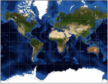
There are many type of map projection. Some score well on one or some of the above attributes and others are an attempt at getting the best compromise on all four. Take a look at the following map of the world, made using the well known Mercator projection.
Compare it with the following map made with a Mollweide projection. Look at the relative sizes of Africa and Greenland in both maps.
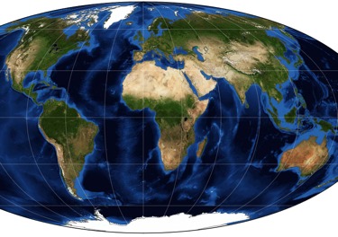
Africa is 14 times the size of Greenland. The Mollweide projection accurately represents areas, whereas the Mercator projection exaggerates the areas as you get closer to the pole. However, the Mollweide projection shears the shapes near to the poles.
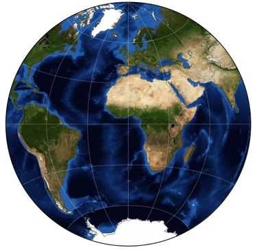
The azimuthal equidistant projection provides a compromise between conformal and equal-area projections.
There are many map projections in use. If you're interested, take a look here for a much more extensive and technical introduction to projections.
New Zealand Projections
New Zealand Map Grid (NZMG) has been the map projection used for general mapping. The widely-used topographical maps published prior to Sep 2009 use NZMG. Based on the NZGD 1949 datum, this projection was specially crafted for use in New Zealand as a best compromise of the map distortions mentioned above.
NZMG has been replaced by the New Zealand Transverse Mercator projection for small scale mapping. Such a change doesn't happen overnight and a mixture of coordinate systems will be in use for some time.
NZTM is covered in more detail in this article
Copyright © 2009 Integrated Mapping Ltd. All Rights Reserved. This article may not be reproduced without permission.
MapToaster for iOS
MapToaster for iPhone and iPad now with November 2024 maps, including mainland New Zealand, Chatham Islands, Raoul Island & Kermdec Islands, Auckland Island, Campbell Island, Snares Island, Antipodes Island and Antarctica in the Ross Dependency area, check it out.
Intro to Geocaching
An Introduction to Geocaching
Maps for your GPS

Now available - MapToaster Mobile/NZ provides topographical maps for your Garmin outdoor mapping GPS. This is a companion for MapToaster Topo/NZ for your computer. more »
Colorado 300 Review
Check out out our review of the Garmin Colorado 300 GPS. more »
Who Makes MapToaster
MapToaster Topo/NZ was developed in Christchurch by Integrated Mapping The company, which was established in 1992, has considerable expertise in building mapping and GIS solutions and is 100% New Zealand owned.