Geocaching
Looking for an outdoor activity for the kids? Have some time to spare and need a destination? Then check out geocaching.
Geocaching is described as a high-tech treasure hunt. The objective is to find a geocache, a waterproof container with a log book and perhaps some small items to exchange. The geocache creator hides the container in the outdoors, then posts details on a geocaching website.
To play, you use a geocaching website to select a cache you'd like to find. The website will list a description, some map coordinates and possibly cryptic instructions for locating the container.
When you find the cache, record your find in the log book, and later record it on the website. The cache may also contain a number of small trinkets. You may take one with you if you have one to leave in return.

There are over half a million caches in 100 countries around the world. Locations range from urban to mountain tops.
Things You'll Need
- A hand-held GPS reciever. A basic recreational GPS, a mapping handheld GPS (e.g. Garmin 60CSx or Oregon), a smartphone with geocaching software (e.g. iPhone, Android or Windows) or a battery powered in-vehicle GPS could all be used. More advanced units that can display maps will be a help. Some GPS's include "paper-less" geocaching features that let you manage all the geocache information directly on the unit.
- Computer with internet acesss (unless you're using a smartphone with paperless features).
- Items for trading - more on this later
- Pencil (they write in the wet) and a notebook for logging your finds
- Plastic rubbish bag - see later under cache-in-trash-out
- Extra batteries for the GPS
If you don't have a GPS, check out our guide on choosing a GPS.
Websites
There is no official central geocache database. Two websites with lots of New Zealand caches are
You can connect with members of the New Zealand geocaching community on the forums of the NZ Recreational GPS Society
Other useful websites:
- EarthCaches - geocaches of geological interest
- Flickr geocaching group
- Educaching.com
- KiwiCaching - local, NZ, geocaching group
Finding a Cache
Use one of the geocaching websites to select a cache to visit. Program your GPS and head off. Here are the steps in more detail. Click on the images below, for a better view
 Many of the pictures below have this magnifying-glass symbol. Click on the picture for an enlarged
view.
Many of the pictures below have this magnifying-glass symbol. Click on the picture for an enlarged
view.
Create an account at one of the geocaching websites listed in the Websites section, below. A paid premium account offers extra features, but for now a free one will do. We're going to use geocaching.com.
Choose a geocache to hunt. Geocaching.com has a search box on the home page. This lets you find caches near a location. Pick somewhere close by for your first find.
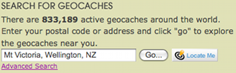
You'll get a list nearby caches, sorted by how close they are. The symbol shows the type of cache and there's a brief description. The are various icons on the page that tell you the type of cache and indicate other features. Click on the icon to see what it means.

It might be easier to use the map view. Click the Search for caches with Google Maps link at the top of the page.

Pick a nearby cache that appeals to you. For a start, choose an easy one. The Difficulty and Terrain have scores from 1 to 5 where 5 is the hardest. The cache name on the results page is a link. Click the link to see the details for the cache. Print the cache page, or copy the details into your logbok.

Program your GPS with a waypoint. You can do this on the GPS by creating a new waypoint and typing in the latitude/logitude coodinates. If you have software on your PC such as Garmin MapSource or our MapToaster Topo/NZ, you can create whatever waypoints you need them download them to the GPS.
If you have a smartphone with a GPS and geocaching software, you can select and download the cache information directly onto the device.

Geocaching.com has a feature called Pocket Query for Premium members. This allows you to select and download a GPX file containing a selection of caches, together with the the full information about the cache. If you have software, such as MapToaster Topo/NZ, that supports Pocket Query, the geocache information can be viewed on-screen and downloaded to your GPS. There's more on this in the software section below.

If you have a GPS that supports paperless geocaching, the all the cache information will be transferred to the GPS as well. The example below shows what you see on a Garmin Oregon GPS. When you decide on a cache, click the "Go" button to navigate to it.

Find your Geocache. On your GPS select the waypoint that you created for the geocache. The GPS will show the distance and direction to the cache. Most GPS's have an arrow navigation page that's good when you're getting close.

The GPS is going to get you to within 10 metres or so of the destination. Follow the clues in the cache description. Remember that the cache is hidden

If you're hunting for a Multi-cache or a Puzzle cache, there will be more work to do.
Success!
The cache will contain at least a log book (micro-cache). There maybe be Items to exchange. And possibly geocoins or travel bugs - see the Terminology section below for more on these two. Don't take a travel bug unless you are able to place it in another suitable cache.

Finally, make sure that you log your cache on the geocaching website that you use.
Keeping it fun
There are some basic rules to follow.
- Don't forget the usual outdoor precautions if you are venturing out of town: warm clothing; map and well as GPS; food and drink; tell somewhere you are going and when you'll return.
- You can make a great contrbution by removing rubbish that you see while you're on the hunt.
- If you take something from the cache, leave something as good or better. If the cache has a theme, stick to the theme. If the cache is poorly stocked with exchangeable items, consider leaving an item, but not taking one.
- Take care to properly seal and replace the cache as you found it when you're done.
- We live in paranoid times. There have been instances where caches or the activities of geocachers have been interpreted as sign of criminal activity or worse. The results has been police call-outs and bomb scares. Keep this in mind when designing and placing caches - you don't want to be the centre of a bomb scare (this has actually happened).
- Avoid placing caches on private land.
- Avoid placing caches in places where that might be sensitive from an ecological point of view. For example, in National Parks etc, stick to areas that are already well trodden. The goverment agencies responsible for public land may have their own guidelines.
- Don't place caches where those looking for the cache could be injured. Remember that they don't know where it is, so they might not take the most direct route.
- If you place a cache you need to be prepared to maintain it and ultimately remove it
Software & Maps
You don't need any software beyond a web browser, to enjoy geocaching. However, there are tools that make managing the geocache data easier.
Our own MapToaster Topo/NZ software is able to read geocaching.com LOC, GPS and Pocket Query files (PQ files are GPX files that contain extra geocache information). If you open a Pocket Query file in MapToaster, you will see a list of the geocaches. The geocache symbols are colour coded by type.

If you double-click a geocache symbol on the map, a windows opens that shows the full detail for the cache. You can print the instructions to take with you and there is a button to jump to the cache page at the geocaching.com website.

Geocaching Swiss Army Knife (GSAK) is a comprehensive package for managing geocache lists. It is packed with features and widely-used.
There is geocaching software for GPS equipped smartphones and other mobile devices. This software manages all your geocaching information. Wireless data lets you search geocaching.com when you're on the move. You can find a nearby geocache, download the cache description, then use the GPS in the phone to find the cache. Once you're done you can wirelessly log the find.
For the iPhone, there's the MapToaster for iPhone and iPad app, available from the Apple AppStore. You can download PocketQuery files from geocaching.com and view all the cache details on your phone.


Geocaching.com has comprehensive software list
Terminology
Some of the language used in geocaching is not obvious. Here's a quick guide.
 Geocoins are specially minted for geocaching. They may have a serial number that
can be used for tracking them on an Internet geocaching website. Geocoins may be personal
designs, or minted by a group or club. They are collected and traded or more often
moved from cache to cache with progress being recorded on a website.
Geocoins are specially minted for geocaching. They may have a serial number that
can be used for tracking them on an Internet geocaching website. Geocoins may be personal
designs, or minted by a group or club. They are collected and traded or more often
moved from cache to cache with progress being recorded on a website.
Muggles are those not part of the geocaching community or are not familiar with the activity (from the Harry Potter books). Geocachers are often looked at askance by muggles. A geocached that has been deliberately damaged or removed is said to have been muggled.
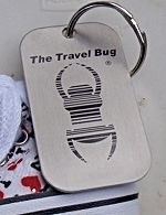 Travel Bugs are a metal tag with a unique serial number, intended to be
moved from cache to cache. Progress and the travel stories are
recorded at the geocaching.com website.
If you find a travel bug, move it and don't hang on to it. Some travel bugs want
to go to a specific location.
Travel Bugs are a metal tag with a unique serial number, intended to be
moved from cache to cache. Progress and the travel stories are
recorded at the geocaching.com website.
If you find a travel bug, move it and don't hang on to it. Some travel bugs want
to go to a specific location.
GPX file format is the most common format for exchanging GPS data. It is widely supported. The GPX format geocache data you get from geocaching.com includes extensive information on each cache. Many of the more advanced GPS units can use these files and out MapToaster Topo/NZ supports them as well.
KML file format is the Google Earth format and is widely supported by other software.
LOC file format is the original file format used by geocaching.com.
Waymarking is similar to geocaching, but there is no cache container or log at the location. A waymark is a physical location. The starting point for waymarking is http://www.waymarking.com
Types of Caches
Traditional Cache - this is the original basic cache type. It consists of at least a container with a log. The coordinates recorded for the cache are its exact location. The container is a waterproof plastic bucket or ammo box. The container may or may not include goodies for exchange. If it does, the rule is to leave an item to replace any item that you take. If it is a themed cache take something appropriate for the theme. A micro cache is variation of a traditional cache that has a very small conatiner and only a logbook inside.
Mystery/Puzzle Cache - you have to solve a (possibly elaborate) puzzle to find the cache location. You may have to derives the coordinates, or discover information along the way to enable you to access the cache. Here's an example (quoted from Stern Bird by Gyargh):
At the given co-ords you will find a stern looking bird. This cache requires a short walk past some interesting sculptures and a little math .... Starting at S 43 30.661, E 172 38.763 (the given co-ords); follow the stream down the footpath. Along the way you will see four wooden sculptures. At each sculpture, take note of the street number of the house it sits outside. Bird 1 = A, bird 2 = B, bird 3 = C, bird 4 = D. You do not need to go past S 43 30.657, E 172 38.896 Use the numbers you have gathered to work out the following equations, which gives the location of the cache... E 43 30. (4A + 8B + 3) S 172 38. (2C + 4D + 5) To check you have the right numbers: A + B + C + D = 391
Multi-Cache - has two or more locations. Typically the first location has hints for finding the second and so on, leading to the final location with the actual cache. The name "offset cache" is sometimes used where a recorded location contains information that lets you decode the coordinates of the actual cache.
Letterbox Hybrid - a combination of a geocache and a letterbox. The cache will contain a unique rubber stamp to stamp your logbook. You can also have your own stamp to stamp the cache log. This type of cache might not have items for exchange.
Wherigo™ Cache - this in a sense is like a multi-cache. There is a Wherigos story file that called a cartridge. You also need a cartridge player - software for a PDA or smartphone, or a GPS that supports Wherigo cartridges.
Event Cache - this is a event organised for geocachers and often involves caches placed specifically for the event. A cache-in-trash-out is an event organised for the purpose of cleaining up the enviroment. A mega-event is an event cache involving more than 500 people.
EarthCache - found at locations of geological significance. Their purpose is educational. http://www.earthcache.org/ is the website for EarthCaches. There is no container or log book.
Virtual Cache - these have no logbook or container. The cache is the location itself and is selected as a place of special interest The proof-of-visit is by sending the person who created the cache a specific piece of information from the site or by sending a photo of yourself and GPS at the location. Virtual caches are now part of waymarking.
Webcam Cache - a variation of virtual caches where the objective here is to obtain a photo of yourself with a public web cam. Webcam caches are now part of waymarking.
Locationless Cache - really the inverse of a traditional cache. You are given a description of the object to find. You must return the coordinates of the object. Webcam caches are now part of waymarking.
Copyright © 2009-2014 Integrated Mapping Ltd. All Rights Reserved. This article may not be reproduced without permission.
MapToaster for iOS
MapToaster for iPhone and iPad now with November 2024 maps, including mainland New Zealand, Chatham Islands, Raoul Island & Kermdec Islands, Auckland Island, Campbell Island, Snares Island, Antipodes Island and Antarctica in the Ross Dependency area, check it out.
Maps for your GPS

Now available - MapToaster Mobile/NZ provides NZ topo maps for your Garmin outdoor mapping GPS. This is a companion for MapToaster Topo/NZ for your computer.
60CSx Review
Our review of the GPSMAP 60CSx GPS
Oregon Review
Check out our review of the Garmin Oregon 300 & 550 GPS.
Colorado Review
And our review of the Garmin Colorado 300 & 550 GPS.
Who Makes MapToaster
MapToaster Topo/NZ was developed in Christchurch by Integrated Mapping The company, which was established in 1992, specialises in building mapping, GIS and GPS software and is 100% New Zealand owned..