Garmin Oregon Review
Garmin has followed the Colorado with the release of the Oregon outdoor mapping GPS. The highlights of this unit are:
- touch screen user-interface
- high-resolution colour screen - 240x400 pixels, 76mm (3") transreflective screen.
- high-sensitivity receiver
- barometric altimeter, electronic compass
- paper-less geocaching features
- 850 MB of internal memory and a microSD card slot
- camera in the 550 model
Hardware
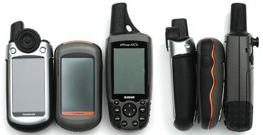
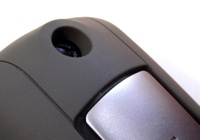
The photo above shows the Oregon compared with a Colorado, left, and GPSMAP 60CSx, right. The Oregon body is a shorter and a little wider than the 60CSx, but about the same size as the Colorado. Unlike the other two units, the Oregon has an internal antenna, making it shorter and less likely to snag on bush etc. The Oregon is 15-20g lighter than the other two - not that noticeable a difference. The rubberised back and sides are comfortable to hold and you feel like you have a secure grip. Apart from the power switch there are no controls on the unit. Everything happens on the touchscreen.
The Oregon has the same 76mm, 240x400 pixel display as the Colorado. Compared to the 60CSx, the high-resolution and greater colour depth make for much better looking maps. The text and linework on the maps appear to be anti-aliased making them very clear and readable.
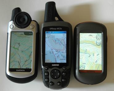
The Oregon screen has the brightest backlight of the three units, as you can see in the photo above, making it the easiest to read in conditions where the backlight is significant. However, in sunlight and bright overcast, the readability is reversed - the 60CSx is the easiest to see and the Oregon the least. This seems to be due to the matt screen surface used on the Oregon. While you can see the maps clearly, it's not nearly as good as the other two units. The Oregon 550 has a has a more or less glossy screen, but it's still not as readable as the 60CSx in bright light.
Also disappointing was how easy it is to scratch the screen. A small piece if grit that cuaght under my finger while dragging across the display made two big scratches. A screen protector solves htis problem.
The screens on the Colorado and Oregon are much less sensitive to viewing angle than the 60CSx screen.
Both the Oregon 300 and 550 have an barometric altimeter and electronic compass. The 550 has the 3-axis til compensating compass that make it easier to use - doesn't have to be held horizontal.
The buttons and Rock n Roller of the 60 and Colorado are replaced by a touch screen interface. The next section describes the controls in more detail.
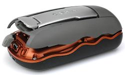
The back of the unit is covered by a rubberised detachable battery cover. Lifting the catch lets you remove the back cover, for changing batteries. The Oregon uses a microSD data card which goes in a slot under the batteries - same as the 60CSx.
Like the Colorado, the back cover has a mounting rail that is used for a selection of mounts that slide onto the rail. The carabiner mount, supplied with the unit, works well for securely attaching the unit to a shoulder strap or belt. The car mount uses the same mounting rail and it's much easier to use than the 60CSx's car mount.
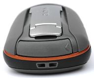
The USB connector is under a rubber cover on the bottom end of the unit. There is also an attachment for lanyard. There is no connector for an external antenna.
The rubber seal for the battery compartment is deeply recessed - not as easy to clean as the other two units. Garmin say the unit is IPX7 waterproof, and does not float.
Battery life seems similar to the Colorado and is shorter than the 60CSx. The Garmin manual says up to 16 hrs. With 2500 mAh NiMH batteries I was getting 8-10 hrs of reasonably heavy use. How much you use the backlight, redraw the maps and have the compass turned on etc will affect the life. Colorado firmware updates have included battery life improvements, so it's worth checking your unit's firmware is up-to-date. If you're using NiMH batteries, you should take set of batteries per day if you plan on having the unit on continuously.
For use in the car, there is a car kit with a suction windscreen-mount and a special lighter power cable that plugs into the USB port on the unit. The power cable for the Colorado car-kit does not fit the Oregon. The rail mount of the Oregon and Colorado make the unit a lot easier to get unit on/off the car mount than the 60CSx.
The Oregon apparently uses a different GPS chipset from the 60CSx and Colorado. Unscientific tests under challenging conditions gave similar results for all three units. Other have reported the Oregon receiver isn't as good, but this didn't seem to be the case. The time to fix was similar to the other units.
Touch Screen
The power button is the only control on the Oregon. All other functions are controlled by the touchscreen. The screen has a slightly soft feel and your finger slides easily over its surface.
There is no problem using the screen when the GPS and your hands are wet. The on-screen buttons on the user interface are large enough to be used with gloved hands.
As noted in the previous section, the matt surface of the screen makes it harder to see the maps in bright light and it's fairly easy to scratch.
Oregon 550 - Has Camera
The Oregon 550 looks the same as the Oregon 300, except that it has a 3.2 megapixel (2048x1536 pixels) camera on the back. The camera has autofocus and is able to focus close enough to get a 50mm object full frame. There are lower resolution settings, but with the storage available on the device and data cards means there's no reason to use anything but the highest resolution.
The camera lens is deeply recessed providing good protection and a degree of shielding from direct sunlight. The camera lens is exposed for easy cleaning when the back cover of the GPS is removed.
The picture quality is similar to a high-quality camera phone, but not as good as the ruggedised 5 megapixel Olympus 1030SW we compared it with. There's no flash. Low-light photos show noise, as you'd expect with a camera with a small lens and imaging element.
If the GPS has a lock when the the photo is taken, the photo is tagged with the lat/long of where you are standing. Such photos are said to be geotagged. MapToaster Topo/NZ can open a series of geotagged photos and automatically create linked waypoints for them.
Custom Maps
The latest firmware for the Oregon, Dakota and Colorado GPS units includes the ability to load raster maps and aerial photos onto the GPS.
If you have MapToaster Mobile/NZ on your GPS, the linework, e.g. roads, tracks, fencelines, rivers, etc are drawn over the top of the aerial photo.
Note that this facility is not a substitute for MapToaster Mobile/NZ. The raster maps and imagery that you can upload are limited to a fairly small areas and lack the Find index that the GPS product provides.
User Interface
The main menu is organised into four pages of six icons. These icons provide access to the maps, searching, tracks and waypoint mangement, GPS setup, compass, trip meter and many other functions that will be familiar to a Garmin user.
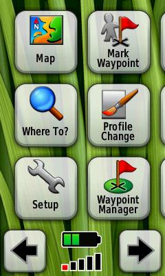
You move between the pages either by dragging across the screen with your finger or using the arrow buttons at the bottom of the screen.
There are battery and GPS signal strength indicators at the bottom of the menu screen. Tapping the signal strength icon opens the satellite signal screen.
The icons on the menu pages can be re-organised to suit your preference. The GPS also has profiles. There are pre-defined profiles for Recreational, Geocaching, Automotive, Marine and Fitness use. The profile allows you to remember all your settings for a particular activity, then switch between them quickly.
The map is moved by dragging on the screen. Zoom in/out buttons are in the top-right corner and are nicely translucent so as not to obscure that map any more than is necessary. The map view is very easy to navigate around in.
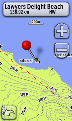
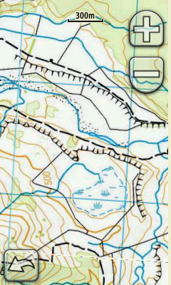
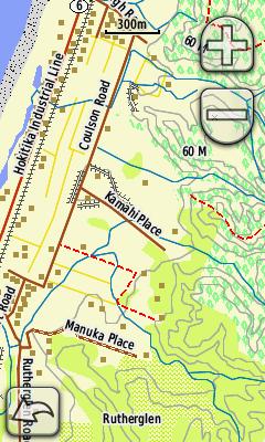
If you tap on the map, a pin appears. There is also a bar at the top that shows the detail about the POI or map feature that the tip of the pin touches. In the image, above, the pin is touching the POI for Lawyers Delight Beach and you can see the pin is 138km NW from our current location.
As you drag the map, the pin stays at the same location on the screen. So you can see the info about features by dragging them under the tip of the pin. On the Colorado or 60CSx, you would do the same thing by moving the mouse pointer over an object.
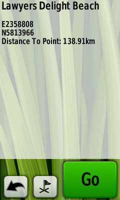
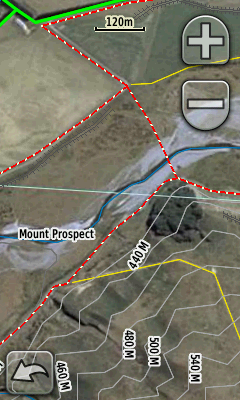
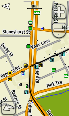
If you click on the bar at the top of the map, you will drill down into the screen with more detail about the POI or map object, see above. At the bottom of the detail screen there are buttons to save the point as a waypoint or to begin navigating to that point.
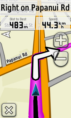
With suitable maps loaded the Oregon also provides on-road routing. The displays are clear and will be familiar to Garmin users. There are no voice prompts.
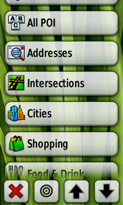
Find
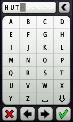
Selecting the "Where To" button on the main menu display a list of search categories. The search function does a sliding match for what you type. Entering "HILL" matches Hillsborough, Marleys Hill etc. The list of results is sorted by distance from the search location. There is no equivalent to the 60CSx Find by Name function.
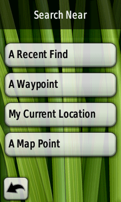
Selecting the second button from the left on the Where To page displays the "Search Near" page. This allows you to select the location that you want to search from. You can pick your current location, a recent find, a waypoint or "A Map Point" lets you position the pin anywhere on the map.
A big win for the touch screen is having a keypad to enter letters and numbers. This is so much easier to use than the buttons or Rock 'n Roller of the 60CSx and Colorado.
Maps
The Oregon 300 and 550 have no detailed built-in maps. There is a world-wide map that includes relief-shaded terrain that is quite coarse. At the 5km zoom level, or more zoomed out, it gives a nice impression of the land form, but generally is best left turned off.
We've tried the Oregon with our own MapToaster Mobile/NZ topo maps and with NZ Open GPS Maps routable maps. The maps look great on the large high-resolution screen.
Track handling is an improvement over the Colorado. You can control whether individual tracklogs are displayed on the map and you can set the colour as well. This is the same level of control as you get with the 60CSx.
Geocaching
Like the Colorado, the Oregon has support for paperless Geocaching. You can load geocaching.com Pocket Query files that contain comprehensive infoemation on the selected geocaches. You can mark caches as found and use Field Notes. Our Colorado review covers the Colorado features in more detail and there's a Oregon geocaching FAQ
Connecting to a Computer
When you connect the Oregon to your computer with a USB cable, the GPS enters USB mass storage mode. The internal memory and SD card appear on your computer as a drive letters (e.g. they might be E:\ and F:\ drives). The Garmin Trip and Waypoint Manager software recognizes these drives as belonging to a GPS and will transfer the waypoints and tracks to/from the unit in the usual way.
When you connect to the computer, the GPS copies the tracks and waypoints, that it stores internally, into GPX files that you can access on the drive letters that are created. If you have a big track log this process can take a while - too long if you're in a rush.
When you unplug the Oregon from the computer, the unit shuts down and must be restarted to restore GPS function - not entirely convenient.
The Oregon USB inteface can also be set to what's called Spanner mode which provides real-time tracking over the USB interface, but you don't seem to be able to transfer waypoints and tracks in this mode. I've found spanner mode is not entirely reliable. Spanner does not work with Windows Vista.
Saved or archived track logs are handled better than the 60CSx. The track log holds 10,000 points. When this limit is reached, the first 2000 points in the log are archived automatically, rather than just being overwritten. Up to 200 track logs can be saved. Even better, all the track points are saved in the archived log. On the other Garmin handhelds, you lose the timestamps when you save a track and the number of points in the track is reduced. The Oregon preserves both the timestamps and all the track points.
On the Downside
In our Colorado review, there was a list of features that the 60CSx had that the Colorado didn't. The Oregon addresses most of those shortcomings and adds some of its own:
- The screen is the biggest weakness of the Oregon. The matt surface of the 300 screen means it's not as easy to see as the glossy screens of the 60CSx and Colorado - it is readable though. The 550 screen is more glossy and an improvement on the 300. The touchscreen is far too easy to scratch - a screen protector is recommended. We've found ClearTouch to work well.
- MapSource software was not included. Though BaseCamp and RoadTrip are free downloads.
- Search - the 60CSx has two search modes when you use the "Find" facility. "Find by Name" locates POI that start with the letters that you have typed. It is very fast and allows you to locate places anywhere in the map. It useful for repositioning the map a long way from where you are. "Find Nearest" locates POI close to the currently displayed map postion. It's used to find nearby huts or gas stations or whatever. The Oregon and Colorado only have the "Find Nearest" function. If you want to view the map away from the current position, the only option is to use "Find Nearest" and hope it finds it before it gives up or to manually scroll the map there - too bad if you don't know exactly where that place is exactly.
- All the options for controlling map display options are accessed from the Setup page. They're not all collected together on the map page menu like thay are on a 60CSx. This is a step backwards from the Colorado which did have some settings in the map view. You can overcome this weakness to a degree by setting up your profiles for walking driving etc and moving the Profile Change button onto the first page of the main menu, to be beside the map button for quick access.
Summary
The Oregons are very nice GPS units. The touchscreen interface is very easy to use. While the 60CSx still has some features the Oregon lacks and the easiest-to-see screen in bright light, the Oregon firmware, high-resolution screen and touchscreen the Oregon are compelling, especially if you do geocaching. If you create a lot of waypoints or do a lot of searches, the on-screen keyboard will save you a lot of time. Also the smoothly rounded case with no external antenna make the unit feel very compact.
The Oregon 550 costs about $140 more than a 300, not a bad deal to get camera, a 3-axis compass, rechargable batteries and charger.
The Oregon is the most used GPS in our office.
Other Resources
The User Manual is available for download from Garmin. The Oregon Wiki has a wealth of information about this unit.
Any Questions?
If there's anything you'd like to know about the Oregon I haven't covered, and I'll add it (BTW, we don't sell GPS units).
JM - Oct 2008, updated Oct 2010
Copyright © 2008-2009 Integrated Mapping Ltd. All Rights Reserved. This article may not be reproduced without permission.
New
MapToaster Mobile/NZ V9.0
is now available, with updated maps. More...
New
MapToaster Topo/NZ V9.0
is now available, with updated maps and aerial photos. More...
MapToaster for iOS
MapToaster for iPhone and iPad now with November 2024 maps, including mainland New Zealand, Chatham Islands, Raoul Island & Kermdec Islands, Auckland Island, Campbell Island, Snares Island, Antipodes Island and Antarctica in the Ross Dependency area, check it out.
Intro to Geocaching
An Introduction to Geocaching
Choosing a GPS
Some thoughts on buying a GPS
Maps for your GPS

Now available - MapToaster Mobile/NZ provides NZ topo maps for your Garmin outdoor mapping GPS. This is a companion for MapToaster Topo/NZ for your computer.
62s Review
Our review of the Garmin GPSMAP 62s GPS.
60CSx Review
Our review of the GPSMAP 60CSx GPS
Colorado 300 Review
And our review of the Garmin Colorado 300 GPS.
Who Makes MapToaster
MapToaster Topo/NZ was developed in Christchurch by Integrated Mapping The company, which was established in 1992, specialises in building mapping, GIS and GPS software and is 100% New Zealand owned..