New Zealand Transverse Mercator
In 2001 Land Information New Zealand (LINZ) adopted New Zealand Transverse Mercator (NZTM or NZTM2000) as the new standard coordinate system for general mapping in New Zealand. This coordinate system is gradually replacing New Zealand Map Grid (NZMG).
In the September 2009 LINZ released a new series of topographical maps, projected in NZTM.
What does this mean for me?
Your existing electronic and paper maps and GPS technology will continue to be usable, but...
- If you use paper topo maps, you're probably going to want to replace them with them with new Topo50 and Topo250 NZTM ones at some stage. MapToaster Topo/NZ version 5, available in October, has the new NZTM maps.
- The maps in your handheld GPS are most likely stored in in lat/long WGS-84 coordinates, so they wont need to be updated. Modern GPS units can probably already display NZTM coordinates. Older GPS units usually have a User Grid setting that can be used. The values to enter are shown in the GPS section at the bottom of this article.
- You should consider converting/storing your map coordinates in NZTM or WGS-84 latitude/longitude units - emergency services will standardise on NZTM. Your GPS-related data is probably already in WGS-84 coordinates, so you don't have to do anything.
Why the Change?
The shape of the Earth is not a sphere. Its shape is an ellipsoid, which looks like a sphere that has been squashed slightly. A geodetic datum is a mathematical model of that shape. Generally, a datum is not a perfect model.
New Zealand mapping has long used the 1949 Datum (also called NZGD49 or GD1949) for mapping and surveying. By the 1990's, however, the 1949 Datum was showing its age. The datum was no longer accurate enough for survey work. There was a need for a datum that was compatible with global earth models and that could account for the plate tectonics that reshape our country.
The NZGD2000 datum was introduced in 1998 as a solution to these problems.
The NZMG coordinate system that's widely used in NZ mapping has the NZGD 1949 datum "baked in". Therefore, a new datum means that a new projection is also required. New Zealand Transverse Mercator (NZTM2000) as introduced in 2001 was the new standard and a replacement for NZMG.
We are now in a transition period where maps from both coordinate systems are in use.
Different Coordinates
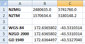
The spreadsheet below shows the coordinates for the Cathedral in Christchurch in different coordinate systems.

As you can see for the GD 1949 and NZGD2000 entries, the latitude/longitude coordinates for a particular location are different depending on the datum used. When dealing with logitude/latitude coordinates, it's important that you know the datum. If you use the wrong New Zealand datum, you will get an error of about 200 metres. Put another way, if you get a 200 metre error, you probably used the wrong datum.
Generally, GPS devices like the recreational Garmin units always use WGS-84 latitude/longitude coordinates. For most uses WGS-84 and NZGD2000 are the same.
The coordinates of a point for NZMG and NZTM differ by approximately 550,000m in the northing and 900,000m easting. For example, the NZMG east/north coordinates for the Cathedral in Christchurch are 2480635,5741760. In NZTM the coordinates are 1570634,5180148. Note that the conversion is a complex equation, not a simple offset by a fixed amount.
For mainland New Zealand you can distinguish between NZMG and NZTM coordinates, by looking at the easting part of the coordinate. For NZMG, the easting coordinate runs from 2,000,000 in Fiordland to 3,000,000 in East Cape. The NZTM eastings run from 1,000,000 to 2,000,000. So for mainland New Zealand you can tell which coordinate system has been used for a point.
LINZ provide an online coordinate system converter. We can help with more complex conversion requirements - drop us an
Paper Topo Maps
The 297 NZMS-260 1:50,000 maps we currently use will be replaced by 452 Topo50 series maps. There will also be new small scale topo maps. The new maps use the NZTM2000 coordinate system. They are also printed in portrait format to make it obvious whether you are using the new map series or the older NZMG maps, which are printed in landscape format.
The new maps will show the same geographic features as the old maps. They are not substantially more up-to-date than the NZMG maps. Some areas will have been updated as part of the regular maintenance cycle, but there has been no overall revision.
If you use topo maps in the wilderness, LINZ recommend that you switch to the new maps, as they are the ones used by emergency services.
Electronic Maps
If you use imagery, like the scanned topo maps or aerial photos in our MapToaster Topo/NZ, you'll need to get an update when the new map series is released.
If your software uses vector maps, the software can probably reproject the maps on-the-fly.
GPS
The maps in your handheld GPS are most likely stored in lat/long WGS-84 coordinates, so they wont need to be updated.
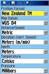
Many Garmin GPS units already have an option to display NZTM coordinates. Garmin 60 series, eTrex, Colorado and Oregon, for example, all have the ability to do this. Look in the menus under Setup. There should be a Units setting. If there is no NZTM option in your GPS, try updating the firmware. The manufacturer may have added it to a later release of the software.

Alternatively, your unit may have the option of creating a "user defined" projection. Enter the following parameters for NZTM:
| Projection | Transverse Mercator |
| Longitude Origin | 173.0 degrees |
| Latitude Origin | 0.0 degrees |
| Scale | 0.9996 |
| False Easting | 1,600,000 |
| False Norting | 10,000,000 |
Coordinate Conversion
LINZ provide an online utility for interconverting between New Zealand coordinate systems.
We can provide software for these conversions. We have add-ons for Microsoft Excel and for MapInfo Professional. for more information
Copyright © 2009 Integrated Mapping Ltd. All Rights Reserved. This article may not be reproduced without permission.
