MapToaster Topo/NZ Version 5.6
This web page details the changes made in MapToaster Topo/NZ version V5.6, V5.5 and V5.0. The current version is MapToaster Topo/NZ V6.0.
If you already have MapToaster Topo/NZ V5.5 or earlier, we'll be sending out emails, with information about how to upgrade.
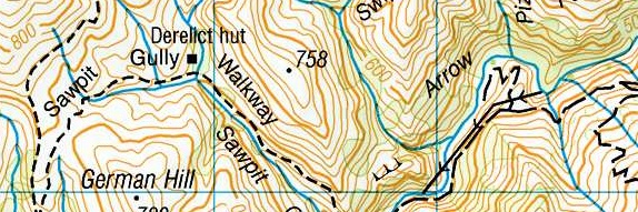
Version 5.6 incorporates the map updates from LINZ up to August 2011, to the 1:50,000 topographic mapping. Forty-four Topo50 maps had either full or partial updates, since MapToaster Topo/NZ V5.5 was released in April 2011. If you have version 5.0 or earlier, over 140 maps have been update compared to your version. Included are updates of DOC huts and tracks. The search facility now includes end-points for the DOC tracks and walkways, making tracks easy to find.
Here's a list of the sheets that have been updated
| Sheet | Name | Edition | Date | Type | ||||
| AW26 | Hokianga Harbour | 2.00 | June 11 | Full Maintenance | ||||
| AW27 | Rawene | 2.00 | June 11 | Full Maintenance | ||||
| AW28 | Kaikohe | 2.00 | June 11 | Full Maintenance | ||||
| AX27 | Aranga | 2.01 | Aug-11 | Selected Update | ||||
| AX28 | Dargaville | 2.01 | Aug-11 | Selected Update | ||||
| AY28 | Te Kopuru | 2.01 | Aug-11 | Selected Update | ||||
| AZ32 | Kawau Island | 1.01 | June 11 | Selected Update | ||||
| AZ36ptsAZ35,BA35,BA36 | Mercury Islands | 1.01 | June 11 | Selected Update | ||||
| BA36ptBA35 | Cooks Beach | 1.01 | June 11 | Selected Update | ||||
| BC33 | Te Kauwhata | 1.01 | June 11 | Selected Update | ||||
| BD36 | Lower Kaimai | 1.01 | June 11 | Selected Update | ||||
| BE43 | Huiarua | 1.01 | June 11 | Selected Update | ||||
| BG36 | Taupo | 2.00 | Aug-11 | Full Maintenance | ||||
| BL34 | Hunterville | 1.01 | June 11 | Selected Update | ||||
| BN24 | Collingwood | 1.02 | June 11 | Selected Update | ||||
| BN33 | Levin | 1.01 | Aug-11 | Selected Update | ||||
| BN34 | Shannon | 1.01 | Aug-11 | Selected Update | ||||
| BP24 | Takaka | 1.01 | June 11 | Selected Update | ||||
| BP25 | Motueka | 1.01 | June 11 | Selected Update | ||||
| BP28 | Te Aumiti (French Pass) | 1.01 | June 11 | Selected Update | ||||
| BP31 | Porirua | 1.01 | June 11 | Selected Update | ||||
| BP32 | Paraparaumu | 1.01 | June 11 | Selected Update | ||||
| BW15 | Okarito | 1.01 | June 11 | Selected Update | ||||
| BW16 | Whataroa | 1.01 | June 11 | Selected Update | ||||
| BX17 | Mount Sibbald | 1.01 | June 11 | Selected Update | ||||
| BY25 | Akaroa | 1.01 | June 11 | Selected Update | ||||
| BZ12 | Makarora | 1.01 | June 11 | Selected Update | ||||
| BZ13 | Haast Pass / Tioripatea | 1.01 | June 11 | Selected Update | ||||
| BZ17 | Burkes Pass | 1.01 | June 11 | Selected Update | ||||
| CA10 | Lake Williamson | 1.01 | June 11 | Selected Update | ||||
| CA11 | Aspiring Flats | 1.02 | June 11 | Selected Update | ||||
| CA12 | Minaret Bay | 1.01 | June 11 | Selected Update | ||||
| CA13 | Lake Hawea | 1.02 | Aug-11 | Selected Update | ||||
| CB10 | Glenorchy | 1.01 | June 11 | Selected Update | ||||
| CB11 | Arrowtown | 1.01 | June 11 | Selected Update | ||||
| CB12 | Cardrona | 1.01 | June 11 | Selected Update | ||||
| CB13 | Tarras | 1.01 | June 11 | Selected Update | ||||
| CD16 | Middlemarch | 2.01 | June 11 | Selected Update | ||||
| CE04 | Anchor Island | 1.01 | June 11 | Selected Update | ||||
| CE05 | Cooper Island | 1.01 | June 11 | Selected Update | ||||
| CG10 | Invercargill | 1.01 | June 11 | Selected Update | ||||
| CG11 | Dacre | 1.01 | June 11 | Selected Update | ||||
| CI04 | Waitangi | 1.01 | June 11 | Selected Update |
MapToaster Topo/NZ Version 5.5
Changes in V5.5
- Version 5.5 incorporates the map updates from LINZ up to April 2011 to the 1:50,000 topographic mapping. Ninety-eight Topo50 maps had either full or partial updates, since MapToaster Topo/NZ V5.0 was released in Sept 2009. Included are updates of DOC huts and tracks.
- Updated support for new models for Garmin GPS units.
- Expanded GPX support. MapToaster Topo/NZ now support GPX V1.1 format as well as V1.0.
- Many minor updates and improvements
Here's a list of the sheets that have been updated
| Sheet | Name | Edition | Date | Type | ||||
| AT24 | Cape Reinga | 1.01 | Oct-10 | Selected Update | ||||
| AU26 | Waiharara | 1.01 | Oct-10 | Selected Update | ||||
| AU27 | Mangonui | 2.00 | April 11 | Full Maintenance | ||||
| AV25ptAV26 | Tauroa Peninsula | 2.00 | April 11 | Full Maintenance | ||||
| AV26 | Kaitaia | 2.00 | April 11 | Full Maintenance | ||||
| AV27 | Mangamuka | 2.00 | April 11 | Full Maintenance | ||||
| AX29 | Tangowahine | 1.01 | Oct-10 | Selected Update | ||||
| AY34 | Claris | 2.00 | April 11 | Full Maintenance | ||||
| AZ30 | Kaipara Harbour | 1.01 | Oct-10 | Selected Update | ||||
| AZ34 | Moehau | 2.00 | April 11 | Full Maintenance | ||||
| BA30 | Helensville | 1.01 | April 11 | Selected Update | ||||
| BA31 | Waitemata Harbour | 1.01 | April 11 | Selected Update | ||||
| BA32 | Auckland | 1.01 | April 11 | Selected Update | ||||
| BB30ptBB31 | Piha | 1.01 | Oct-10 | Selected Update | ||||
| BB31 | Manukau Harbour | 1.01 | Oct-10 | Selected Update | ||||
| BC35 | Paeroa | 1.01 | April 11 | Selected Update | ||||
| BD32 | Raglan | 1.01 | April 11 | Selected Update | ||||
| BD33 | Hamilton | 1.01 | April 11 | Selected Update | ||||
| BE37 | Rotorua | 1.01 | April 11 | Selected Update | ||||
| BG41 | Ruakituri | 1.01 | April 11 | Selected Update | ||||
| BH34 | Raurimu | 1.01 | April 11 | Selected Update | ||||
| BJ31 | Strathmore | 1.01 | April 11 | Selected Update | ||||
| BJ39 | Whirinaki | 1.01 | April 11 | Selected Update | ||||
| BK36 | Taoroa Junction | 1.01 | April 11 | Selected Update | ||||
| BK37 | Tikokino | 1.01 | Feb-11 | Selected Update | ||||
| BK39 | Hastings | 2.00 | April 11 | Full Maintenance | ||||
| BK40ptBK39 | Cape Kidnappers | 2.00 | April 11 | Full Maintenance | ||||
| BL36 | Norsewood | 1.01 | April 11 | Selected Update | ||||
| BN24 | Collingwood | 1.01 | Oct-10 | Selected Update | ||||
| BP23 | Gouland Downs | 1.01 | Feb-11 | Selected Update | ||||
| BP33 | Featherston | 1.01 | Feb-11 | Selected Update | ||||
| BQ23 | Wangapeka Saddle | 1.01 | Feb-11 | Selected Update | ||||
| BQ31 | Wellington | 2.00 | April 11 | Full Maintenance | ||||
| BQ32 | Lower Hutt | 1.01 | April 11 | Selected Update | ||||
| BR20 | Westport | 1.01 | Feb-11 | Selected Update | ||||
| BR21 | Granity | 1.01 | Feb-11 | Selected Update | ||||
| BR23 | Murchison | 1.01 | Feb-11 | Selected Update | ||||
| BS20 | Charleston | 1.01 | Feb-11 | Selected Update | ||||
| BS21 | Reefton | 1.01 | Feb-11 | Selected Update | ||||
| BS27 | Tapuae-o-Uenuku | 1.01 | Oct-10 | Selected Update | ||||
| BT19 | Runanga | 1.01 | Feb-11 | Selected Update | ||||
| BT20 | Ahaura | 1.01 | Feb-11 | Selected Update | ||||
| BT21 | Waiuta | 1.01 | Feb-11 | Selected Update | ||||
| BT22 | Springs Junction | 1.01 | Feb-11 | Selected Update | ||||
| BT23 | Lewis Pass | 1.01 | Feb-11 | Selected Update | ||||
| BT24 | Ada Flat | 2.00 | Sept 10 | Full Maintenance | ||||
| BT25 | Mount Northampton | 2.00 | Sept 10 | Full Maintenance | ||||
| BT26 | Mount Clear | 2.00 | Sept 10 | Full Maintenance | ||||
| BU20 | Moana | 1.01 | Feb-11 | Selected Update | ||||
| BU21 | Haupiri | 1.01 | Feb-11 | Selected Update | ||||
| BU22 | Lake Sumner | 1.01 | Feb-11 | Selected Update | ||||
| BU23 | Boyle Village | 1.01 | Feb-11 | Selected Update | ||||
| BU26 | Parnassus | 2.00 | Sept 10 | Full Maintenance | ||||
| BV19 | Lake Kaniere | 1.01 | Feb-11 | Selected Update | ||||
| BV20 | Otira | 1.01 | Feb-11 | Selected Update | ||||
| BV21 | Cass | 1.01 | Feb-11 | Selected Update | ||||
| BW17 | Harihari | 1.01 | Oct-10 | Selected Update | ||||
| BW18 | Whitcombe Pass | 1.01 | April 11 | Selected Update | ||||
| BW23 | Cust | 1.01 | April 11 | Selected Update | ||||
| BX14 | Gillespies Beach | 1.01 | April 11 | Selected Update | ||||
| BX15 | Fox Glacier | 1.01 | April 11 | Selected Update | ||||
| BX16 | Mount Elie De Beaumont | 1.01 | April 11 | Selected Update | ||||
| BX23 | Lincoln | 1.01 | April 11 | Selected Update | ||||
| BX24 | Christchurch | 1.02 | April 11 | Selected Update | ||||
| BY13 | Lake Paringa | 1.01 | April 11 | Selected Update | ||||
| BY17 | Lake Tekapo | 1.01 | April 11 | Selected Update | ||||
| BZ14 | Mount Barth | 1.01 | April 11 | Selected Update | ||||
| CA08 | Milford Sound / Piopiotahi | 1.01 | Oct-10 | Selected Update | ||||
| CA11 | Aspiring Flats | 1.01 | Feb-11 | Selected Update | ||||
| CA16 | Otematata | 1.01 | April 11 | Selected Update | ||||
| CA17 | Cattle Creek | 2.00 | Sept 10 | Full Maintenance | ||||
| CB08 | Homer Saddle | 1.01 | April 11 | Selected Update | ||||
| CB09 | Hollyford | 1.01 | Feb-11 | Selected Update | ||||
| CB16 | Naseby | 2.00 | Sept 10 | Full Maintenance | ||||
| CB18 | Ikawai | 2.00 | Sept 10 | Full Maintenance | ||||
| CC05 | Colonial Head | 1.01 | Oct-10 | Selected Update | ||||
| CC06 | Caswell Sound | 1.01 | Oct-10 | Selected Update | ||||
| CC07 | North West Arm | 1.01 | April 11 | Selected Update | ||||
| CC08 | Welcome Point | 1.01 | Oct-10 | Selected Update | ||||
| CC18 | Oamaru | 2.00 | Sept 10 | Full Maintenance | ||||
| CC19ptCC18 | Cape Wanbrow | 2.00 | Sept 10 | Full Maintenance | ||||
| CD05 | Dagg Sound | 1.01 | Oct-10 | Selected Update | ||||
| CD06 | Deep Cove | 1.01 | April 11 | Selected Update | ||||
| CD07 | Manapouri | 1.01 | April 11 | Selected Update | ||||
| CD08 | Te Anau | 1.01 | April 11 | Selected Update | ||||
| CD09 | South Mavora Lake | 1.01 | April 11 | Selected Update | ||||
| CD16 | Middlemarch | 2.00 | Sept 10 | Full Maintenance | ||||
| CD17 | Waikouaiti | 2.00 | Sept 10 | Full Maintenance | ||||
| CD18 | Palmerston | 2.00 | Sept 10 | Full Maintenance | ||||
| CE06 | Lake Roe | 1.01 | Oct-10 | Selected Update | ||||
| CF04 | West Cape | 1.01 | Oct-10 | Selected Update | ||||
| CF06 | Lake Poteriteri | 1.01 | April 11 | Selected Update | ||||
| CF07 | Mary Island | 1.01 | April 11 | Selected Update | ||||
| CF12 | Gore | 2.00 | Sept 10 | Full Maintenance | ||||
| CG07ptCF07 | Sand Hill Point | 1.01 | April 11 | Selected Update | ||||
| CG12 | Wyndham | 2.00 | Sept 10 | Full Maintenance | ||||
| CH12 | Waipapa Point | 2.00 | Sept 10 | Full Maintenance | ||||
| CJ09 | Mount Allen | 1.01 | Oct-10 | Selected Update |
Changes in version 5.0
The most important change is that the mapping is now in the new New Zealand Transverse Mercator project (NZTM 2000). The NZMS260 and 262 series have been replaced with the new Topo50 and Topo250 series. The other maps, aerial photography and satellite imagery are also now NZTM 2000 projection.
The Topo50 maps have had extensive updates of the huts and tracks using data from the Department of Conservation.
Topo50
NZTM Support
Version 5 fully supports NZTM. You can use or display NZTM, NZMG or WGS-84 longitude/latitude coordinates. ESRI Shape files in all three coordinate systems supported. The Excel, MIF and tab-delimited text formats include coordinates in all three coordinate systems.
Garmin Oregon and Dakota Support
Garmin GPS mass storage style GPS units like the Oregon, Dakota, Colorado and Nuvi all appear on your computer as a removeable disk drive when you plug them in. MapToaster V5 autodetects these units and provide simple transfer of tracks and waypoints to/from the GPS.
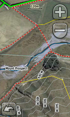
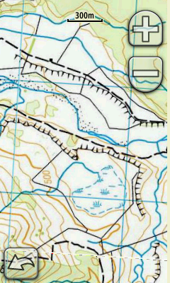
Some of the Garmin outdoor GPS units are able to display raster imagery. These include theOregon, Dakota, Colorado. MapToaster V5 provides an easy way to select transfer and manage aerial photo and topomaps on your GPS.
|
|
If you have MapToaster Mobile/NZ on your GPS, the linework, e.g. roads, tracks, fencelines, rivers, etc are drawn over the top of the aerial photo.
Note that this facility is not a substitute for MapToaster Mobile/NZ. The raster maps and imagery that you can upload are limited to a fairly small areas and lack the Find index that the GPS product provides.
Improved Find Dialog
The Find dialog is now even easier to use. It can search placenames, road names, localities, map sheets, 6-digit map references and coordinates and NZTM, NZMG or WGS-84 cooridnates. You can also click on the reference maps and see list of nearby places. The results can be sorted by name category, distance away or a combination of these.

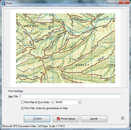
Improved Printing
The print dialog now lets you scale and drag the map to get exactly the view that you want, before you print. The grid labels on the maps are also more readable.
Google Earth Support
You can open and save KML files. This allows you to view you tracks and waypoints in Google Earth or import lines and points from Google Earth into MapToaster.
When when you save a map or aerial photo view to your hard drive, MapToaster now saves a Google Earth overlay file so that you can view the map or aerial photo in Google Earth.

Click to enlarge image
Other Improvements
- Automatically create linked waypoints from geo-tagged photos. If you have a cellphone that has a GPS, or you geo-tag photos in services like Flickr or Picasa, the images have their latitude and longitude embedded in them. MapToaster can read these images and create waypoints with links to the photo.
- When drawing a track you can use the arrows keys to move the map and +/- keys to zoom in/out. This lets you draw tracks of unlimited length.
- You can now set the width track lines should be drawn and set a default colour for new tracks.
- The email-a-map function allows you to set up a username and password to log in to secure mail servers, such as GMail, Yahoo Mail or Xtra mail.
- Tested with Microsoft Windows 7.
- Netbook friendly. Works well on a 1024x600 screen. Modest hardware requirements are well suited to netbook use. A great 4WD mapping solution.
- and other usability improvements....